Sailing in Slovenia – Koper, Izola and Piran

helloskipper-adria-boden-icon-14  Download_on_the_App_Store_Badge.svg

Highlights

The Republic of Slovenia lies at the North East corner of the Adriatic Sea, bordered by Italy to the west, Austria and Hungary to the north and Croatia to the south. Landlocked for most of its history, Slovenia had acquired a sliver of coastline on the Adriatic Sea only in 1954, when the territory around Trieste was ceded to Italy and the area from there South to Portoroz became the short, 11 mile coastline of the emerging nation. With the cession of territory Slovenia acquired four principal harbours which can today accommodate cruising yachts and are recommended for sailing holidays. From North to South they are: Koper, Izola, Piranand Portoroz. Most of the harbours, with the exception of Portoroz, which is a modern Croatian holiday resort, are former Venetian settlements with picturesque old towns.  All of them are useful bases for exploring the many tourist attractions of Slovenia, including the spectacular scenery of the Triglav National Park in the Julian Alps; the famous Lippizaner stud at Lipice; the awesome cave systems of Postojna and Skocjan; the much-photographed Lake Bled and Lake Bohinj and several romantically situated castles such as those of Predjama and Bled.

When to visit

Where to go – The most important marinas

Yachts entering Slovenia from Croatia are required to clear in at Piran before proceeding to any of the other harbours.
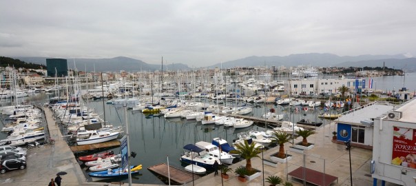
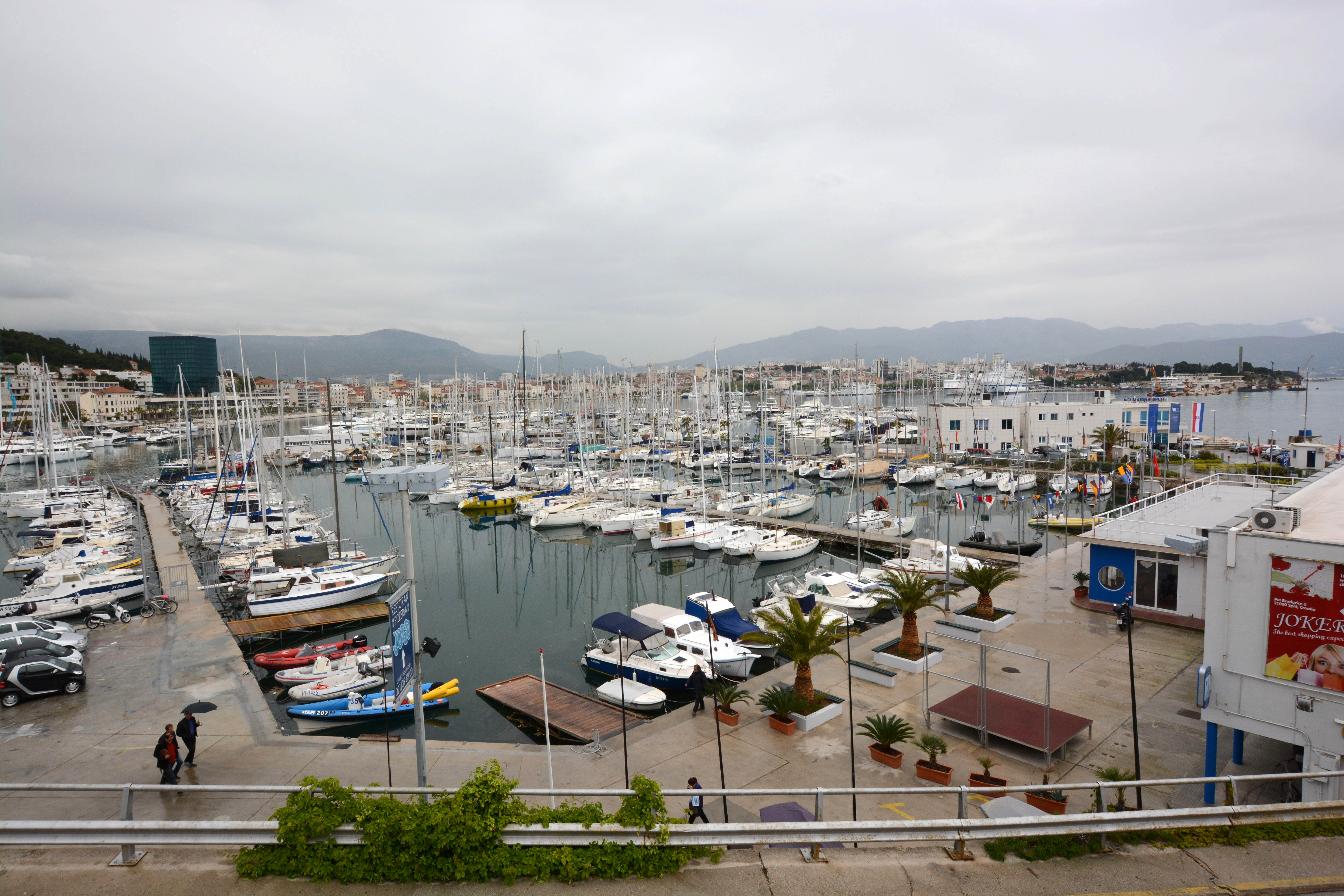
Koper
Marina Koper

The town of Koper lies on the coast of Slovenia three miles S of the border with Italy and four miles E of the harbour of Izola. Is the only commercial port in Slovenia as well as being the most northerly harbour on the country’s short coastline. Originally an ancient island settlement, Koper was part of the Venetian republic from 1232 and became capital of the province of Istria by the 15th century. The town’s influence waned with the establishment of its near neighbour in Italy, Trieste, as a free port in 1719. Most of the remaining Italian population left in 1954 when the town was ceded to the new Federal Republic of Yugoslavia and Koper only began to recover its former importance following Slovenian independence in 1991, when it became the new nation’s only commercial port. In addition to a charming old town, Koper also has a small marina, Marina Koper, offering 75 berths for yachts of up to 18.0 metres, plus a small boatyard that can winter around 25 yachts.

It is possible in settled weather to anchor half a mile SW of the marina, where there is a reasonably sheltered cove S of the long breakwater of the old harbour. Anchor in 4.0 – 5.0 metres clear of the numerous moorings. The holding is good in mud.

The old town of Koper is a delight to explore, with narrow lanes and picturesque houses with red-tiled roofs. Notable buildings include the 15th century Praetorian Palace, a Venetian Gothic confection now used as the town hall; a Loggia Palace originally constructed in 1462, and the city Bell Tower, from which a climb of 204 steps gives magnificent views over the town and harbour.
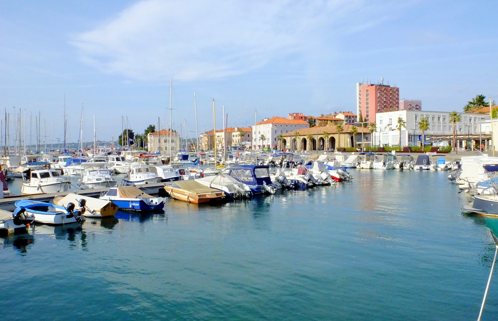
Izola
Marina Izola

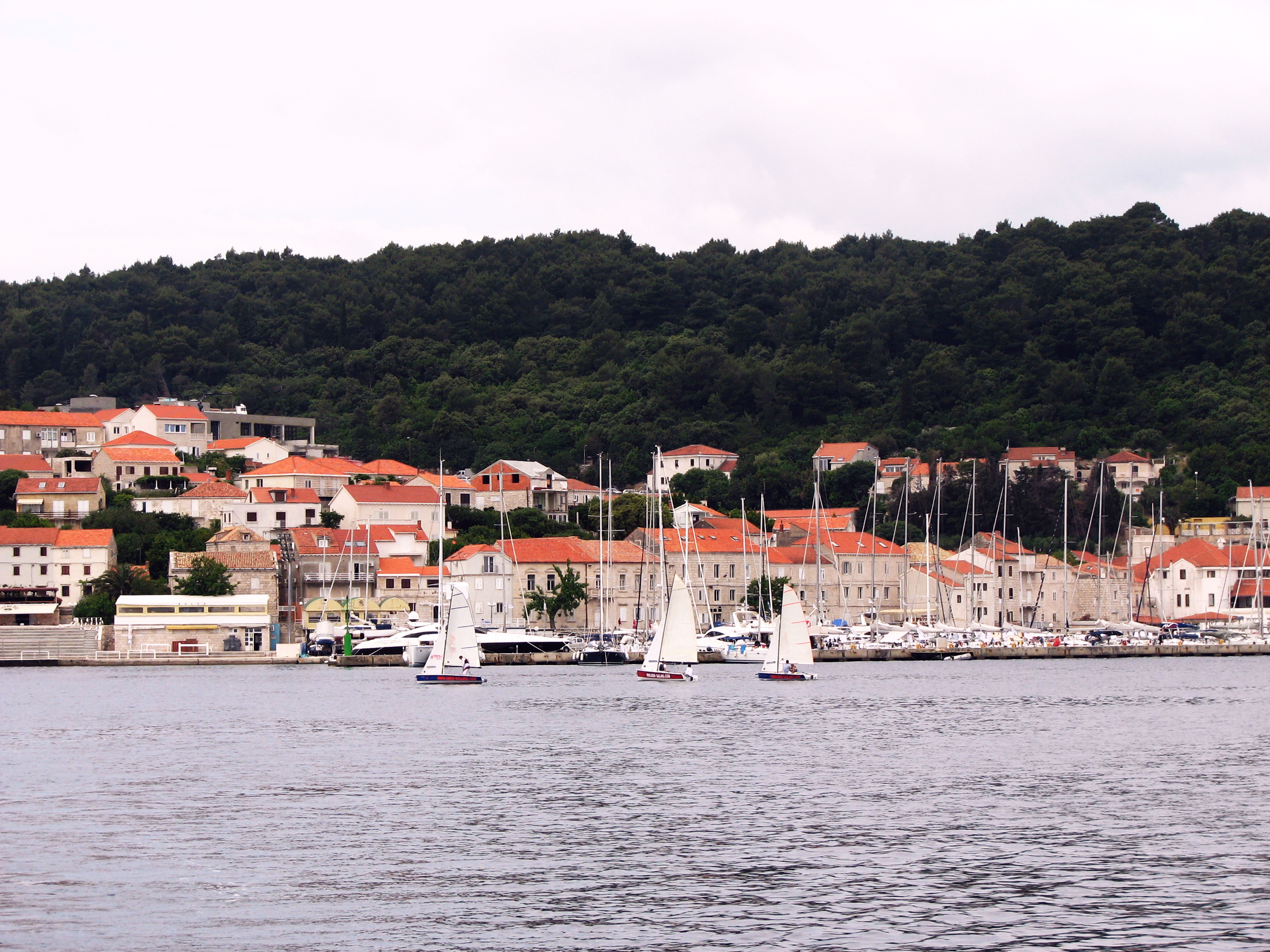
The town of Izola lies on the coast of Slovenia four miles S of the border with Italy and three miles W of the harbour of Koper. Like Koper, Izola was originally an ancient island settlement, becoming part of the Venetian republic by 1267. The period of Venetian hegemony lasted until the arrival of Napoleon’s troops in 1797, after which the defensive walls of the town were demolished and used to fill in the channel separating the town from the mainland. A period of Austrian rule ensued, which ended in 1918 when the area became part of the Kingdom of Italy. As with most of the towns along the Slovenian coast, however, most of the remaining Italian population left in 1954 when the town was ceded to the new Federal Republic of Yugoslavia. Today Izola is a thriving tourist centre as well as having the largest marina in Slovenia, offering 700 berths for yachts of up to 30 metres, plus a boatyard that can winter around 50 yachts.

The marina is entered from WSW along a 75 metre wide channel between two long protecting breakwaters. The E half of the harbour is occupied by small craft moorings and pontoon berths; the W half is taken up by pontoons for larger vessels. Shelter is the marina is good, although strong northerly winds can create a surge at the outermost berths.

While the old town of Izola is not as attractive as those of Koper or Piran, it does share some of the charm of the other two towns, including narrow lanes and picturesque houses with red-tiled roofs. Notable buildings include the 16th century Church of St Maurus with a separate bell tower on the hill dominating the town; the 18th century Besenghi degli Ughi Palace and the 15th century Manzioli Palace in the square of the same name. The town also houses the Parenzana Museum, which holds one of the world’s largest collections of ship and train models. Izola is also a good base for exploring the hinterland of Slovenia, with its world-famous Lippizaner stud at Lipice, impressive cave systems of Skocjan and Postojna and castle of Predjama.
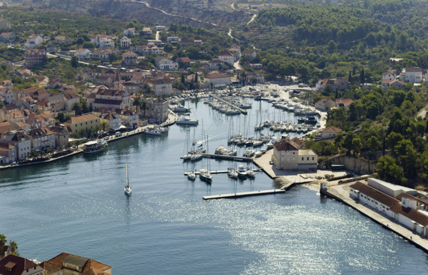
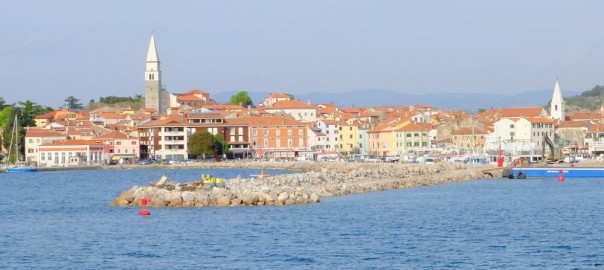
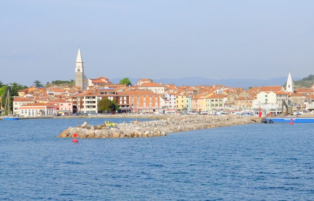
Piran
The town of Piran lies at the tip of a small peninsula on the coast of Slovenia just over four miles WSW of the harbour of Izola and three miles N of the border with Croatia. Piran is one of the architectural jewels of Slovenia, with beautifully conserved mediaeval buildings, streets and squares and lofty town walls barring the land entrance to the town. Most of the buildings date from the period of Venetian or Austro-Hungarian rule. The town’s original fortifications dated from the Byzantine era, although the walls and four high towers across the neck of the peninsular that survive today date from the 16th century, when the greater use of cannon rendered the older walls vulnerable. Several of the old town entrances, dating back as far as the 13th century, still survive in the narrow streets. One of the town’s most famous sons is the violinist and composer Giuseppe Tartini, whose statue still graces the main square named after him today.

The small harbour has space to berth around 20-30 yachts up to 20 metres along its western breakwater in depths of 5.0 – 6.0 metres. It is best visited in settled conditions.

The harbour lies on the SE side of the peninsula and is entered from SSW. The entrance is narrow and a good lookout is needed in case of vessels leaving the harbour. Shelter is good in most conditions, but strong NW winds send in a dangerous surge. In these conditions, Marina Portoroz two miles SE is a safer bet.

Yachts entering from Croatia check in at Piran before continuing N and vice versa. Visiting yachts normally berth stern or bows-to along the western breakwater, where there are laid moorings for around 20-30 yachts of up to 20 metres in depths of 5.0 – 6.0 metres. The berths on the E side of the harbour are for local yachts only.

There are no really sheltered anchorages in the area, although anchoring in the bight immediately N of Marina Portoroz is possible in settled weather.

Piran is a delight to explore, with new sights around almost every corner. The main square of Tartinijev Trg was the inner basin of the harbour until 1894, when it was filled in to create the square.

A statue of the town’s most famous son, the violinist and composer Giuseppe Tartini, stands in the centre. The red-painted house with the balcony at the N end of the square is one of the oldest in Piran and legend relates that is was built by a wealthy Venetian merchant to accommodate his mistress (hence the intriguing inscription on its walls: Lassa pur dir, or ‘Let them talk’).

The church of St George on the hill at the top of the town has fantastic views over the town and the belltower can be climbed for an even better view. Perhaps the most famous view, however, is from the towers of the 16th century walls at the eastern end of the town, which afford a panoramic view of the roofs of the town and, on a clear day, the Grado peninsula on the Italian coast 12 miles NW.

helloskipper-adria-boden-icon-14  Download_on_the_App_Store_Badge.svg

Central Dalmatia – Split, Brac and Korcula

helloskipper-adria-boden-icon-14  Download_on_the_App_Store_Badge.svg

Highlights
Central Dalmatia and it’s biggest city, Split is not only central because it is in the middle of the Croatian coastline but because it is the biggest city of all the Croatian Adriatique and the second most important and biggest city of all the country. Many come to Split to start their Croatian sailing adventures, yacht charter holiday and because of it’s location, which is ideal to start trips from here to visit Milna Brac, Hvar, Korcula, Primosten, Zadar, Sipan and Dubrovnik.

When to visit Croatia
The cruising season opens on Easter but the peak season starts in mid-July when lot of Italian and german yachts invade the coast. During peak season it is often necessary to arrive early to find a berth, and you’ll need a back up plan in case your first choice is full. In the third week of August the visitors disappear just as quickly, leaving the area to the Germans and Austrians who have different holiday times than in southern european countries. All is quiet again through September and October. The most important marinas – where to go

Split

ACI Marina Split
If there is no space in the busy ACI marina (layup ashore and afloat – book ahead!) and you do not want to risk the lack of security on the busy quay, you can easily visit from Marina Kastela North of Split. The city of Split emerged from a settlement around a palace built by Roman emperor Diocletian, and the city was also important within Yugoslavia. Many of the top sights are within easy walking distance of each other, mostly in or nearby the Diocletian’s Palace area. The palace complex is the most important sight in Split.

POI# The Cathedral of St Domnius (Katedrala Sveti Duje) is on the eastern side of the Peristyle. Originally built – at the same time as the palace – as a mausoleum for Emperor Diocletion (who died in 313 AD), his remains vanished a few centuries later, when the city was attacked. POI# The belltower of the Cathedral is well worth climbing for its views over Split, out to sea and inland. On the western side of the Palace is the People’s Square (Narodni trg) on which is the old town hall which was built in the 15th century.

Milna Brac island

ACI Marina Milna-Milna Brac island
Brac is the longest and most elevated island in central Dalmatia. Despite its proximity to Split, Brac is less touristed than the glittering islands of Hvar and Korcula further south. Brac is a relatively dry island; you won’t find the lush vegetation of, say Korcula or Hvar, but there are some lovely spots along the rocky shores and great scuba diving from Lucice Bay. Don’t miss the olive oil in Brac. The olives are of a rare variety called buhavica and there’s over a half- million trees that were planted by the Venetians in the 17th century. The island is also famous for its white stone which was used in the construction of Diocletian’s palace.

Hvar
The city of Hvar is a unique fusion of mediterranean nature, rich cultural and historical past and tourist present. It is situated in picturesque nature, facing the sea. Hvar is an inexhaustible treasury of the scenery, atmosphere and adventure. Hvar gained glory and power during middle ages being an important port within the Venetian, naval empire. Today, it is the centre of island’s tourism in Croatia and one of the favourite destinations of the Dalmatian riviera. Anchorages, that the city of Hvar offers are in port of Hvar and in ACI Club Palmižana on Pakleni Otoci. When docked in the city harbour you can enjoy in day and night atmosphere of the town. Pakleni otoci are one of the favourite nautical destinations on the Adriatic. Palmižana marina is situated in an attractive lagoon on the St. Clement island.

Korcula

ACI Marina Korcula

The central-Dalmatian island of Korcula stretches parallel with the nearby mainland in the west-east direction. It is almost 47 km long, its average width is 5.3 to 7.8 km, and is the sixth largest Adriatic island. The Peljesac Channel, which separates it from Peljesac peninsula, is 1,270 m wide at its narrowest point. The shoreline of the Korčula island is 182 km long, and the shorelines of the nearby islets another 54 km. Korcula is very indented with a large number of bays and coves, which makes it ideal for anchorages. Its north shore is rather low and easily accessible with several natural harbours sheltered from the jugo and easterly winds: Korcula, Banja, Racisce, Vrbovica, Babina, Prigradica. The south shore is more indented but steep in places, with cliffs rising up to 30 m out of the sea. There are many anchorages and bays sheltered from the northern but open to the southern winds: Zavalatica, Rasohatica, Orlandusa, Pavja luka, Pupnatska luka, Prizba, Grscica, Brna etc., and is sheltered from both the bora and the jugo. The island also includes the towns of Vela Luka and Blato and the coastal villages of Lumbarda and Racisce, and in the interior Zrnovo, Pupnat, Smokvica and Cara. Like most of the Croatian islands, the Greeks, who gave it the name Korkyra Melaina or ‘Black Corfu’ for its
dark and densely wooded appearance, first settled Korcula, in the 6th century before Christ, at first next to today’s Vela Luka.

Tips for sailing trips

7-day trip from Split to Zadar
Day 1. Split to Trogir
Day 2. Primosten
Day 3. Skradin (near the National Park & waterfalls of Krka)
Day 4. Zakan (Kornati islands National Park)
Day 5. Isolated bay in Kornati islands National Park
Day 6. Telascica (Kornati islands National Park)
Day 7. Zadar

7-day round trip starting and arriving in Split
Day 1. Split to Maslinica (island of Solta)
Day 2. Skradin (near the National Park & waterfalls of Krka)
Day 3. Island of Kaprije
Day 4. Telascica (Kornati islands)
Day 5. Vodice
Day 6. Primosten
Day 7. Split

14-day trip from Split, finishing in Trogir
Day 1. Split to Lucice (island of Brac)
Day 2. Bol (island of Brac) & Vrbovska (island of Hvar)
Day 3. Port of Hvar on island of the same name
Day 4. Scedro (just off island of Hvar)
Day 5. Port of Korcula on island of the same name
Day 6. Pomena (island of Mljet)
Day 7. Sipan
Day 8 & 9. Dubrovnik
Day 10. Sapemanuelra (island of Mljet) & Skrivena Luka (island of Lastovo)
Day 11. Kopist (island of Lastovo) & Susac
Day 12. Bisevo & Komiza (island of Vis)
Day 13. Visoki Skoji & port of Vis (both on island of Vis)
Day 14. Trogir

7-day trip from Split to Dubronik
Day 1. Split to Milina (island of Brac)
Day 2. Hvar
Day 3. Komiza (island of Vis)
Day 4. Port of Korcula on island of the same name
Day 5. Pomena (island of Mljet)
Day 6. Island of Sipan
Day 7. Dubrovnik

Useful information before leaving

The weather

Bad weather: When a cold front approaches from the west this usually means South/South-East winds starting light and, over 2/3 days, gradually increasing, veering and finally going North West as the front goes through. The process often finishes with a North East bora wind reinforced by the mountainous coast. Periods of thunderstorms are quite common in the northern Adriatic, and can be particularly violent, generating tornados where (for brief periods) winds may reach 40kts, and reverse direction in a matter of minutes as the tornado passes through.Predominant wind, the Bora: very strong, cold Northeasterly wind from the mountains from Croatia and Trieste. It could be a a seriuos threat to navigation but in summer there is very little chance of Bora winds. During winter there is a bigger chance for a Bora that usually lasts 12 hours, maybe 2 days with local gusts up to 40, 60 knots. For more on the Bora, visit Weather Online http://www.weatheronline.co.uk/reports/wind/The-Bora.htm

Good weather: during the summer months it is a general consensus that the Adriatic is a light wind area. Sea breezes may reach a Beaufort5 in the afternoon that drops by night. Land
breezes my develop lighter (Beaufort3) in the morning.Predominant wind, the Jugo: Southeasterly, warm wind. It blows across the Adriatic when a cyclone develops over the Adriatic area. It brings clouds and rain. The air
pressure drops. It develops slowly and it can usually be noticed two or three days in
advance. It usually lasts longer than Bora, five to seven days, and even longer in winter.
There is a possibility of the so called dry Jugo, when it blows for a couple of days without
bringing rain. Unlike Bora, Jugo is a constant wind that gradually gains strength.
The Mistral: Mistral is a “benevolent”, a friendly wind looked forward by especially
sailors and all those who enjoy the summer season under its breeze. Mistral is a daily
wind blowing from the northwest and created by the differences in temperature between
the mainland and sea. It is fairly frequent from spring to autumn and strongest in July
and August. It usually starts blowing around 9 or 10 in the morning, reaches its highest
strength in the afternoon and fades at sunset. Mistral is generally weaker in the north
Adriatic than in its south.

For detailed forecasts you should take into consideration that the nearby islands adiacent to the
coastline will modify the winds: winds resulting from frontal systems and pressure differentials
are likely to be as predicted when more than twenty miles off the Dalmatian coast, close to the
land and amongst islands the wind conditions may vary widely from the forecast.
Avarage wind conditions from Windfinder for Split

http://www.windfinder.com/forecast/zadar_luka

June: dominant wind dir: E; average wind speed: 4 kts; ave temp: 25 C
July: dominant wind dir: NW; average wind speed: 3 kts; ave temp: 30 C
August: dominant wind dir: W; average wind speed: 4 kts; ave temp: 28 C

Summer temperatures: Mediterranean climate characterized by warm and dry summers, mild

and pleasant winters.

The average monthly temperature in July it is 23.9°C (75°F); the average sea temperature in

summer 22.8°C (73°F).

helloskipper-adria-boden-icon-14  Download_on_the_App_Store_Badge.svg